
Category:Maps facing South
English: This category is to collect maps where South is on top while North is downwards.
map orientation | |||||
| Upload media | |||||
| Subclass of | |||||
|---|---|---|---|---|---|
| |||||
Subcategories
This category has the following 10 subcategories, out of 10 total.
H
- Huang He xia you zha ba tu (40 F)
- Huang Yun hu he quan tu (3 F)
M
- Maps of Goa by Linschoten (20 F)
R
- Romwegkarte (Erhard Etzlaub) (16 F)
W
Media in category "Maps facing South"
The following 200 files are in this category, out of 252 total.
(previous page) (next page)-

-
%27_(11074549864).jpg/120px-102_of_%27(Introductory_Text-book_of_Physical_Geography.)%27_(11074549864).jpg)
-
%27_(11110787996).jpg/120px-12_of_%27Practical_general_Continental_Guide_..._Part_I._..._Special_edition_Anglo-American._1875_(76%2C_78%2C_80%2C_83%2C_84)%27_(11110787996).jpg)
-
.jpg/120px-thumbnail.jpg)
-
%27_(11254316323).jpg/120px-151_of_%27Popular_Resorts_and_how_to_reach_them%2C_etc._(Second_edition.)%27_(11254316323).jpg)
-
 1527-TeraFlorida.jpg 1,798 × 941; 283 KB
-
 Europa Prima Nova Tabula - no-nb krt 00485.jpg 4,576 × 3,584; 5.39 MB
-
_32.jpg/120px-Geographiae_Claudii_Ptolemaei_Alexandrini_(Münster%2C_1552)_32.jpg) Geographiae Claudii Ptolemaei Alexandrini (Münster, 1552) 32.jpg 10,592 × 6,752; 7.08 MB
Geographiae Claudii Ptolemaei Alexandrini (Münster, 1552) 32.jpg 10,592 × 6,752; 7.08 MB
-
 Moderna Europae Descriptio.jpg 8,973 × 6,919; 16.44 MB
-
_-_Maurice_Bouguereau_und_Jean_Surhon.JPEG/120px-Karte_von_Vermandois_(1592)_-_Maurice_Bouguereau_und_Jean_Surhon.JPEG) Karte von Vermandois (1592) - Maurice Bouguereau und Jean Surhon.JPEG 975 × 1,566; 543 KB
Karte von Vermandois (1592) - Maurice Bouguereau und Jean Surhon.JPEG 975 × 1,566; 543 KB
-

-

-
.jpg/120px-Hispania_and_Peru_(Giovanni_Battista_Nicolosi%2C_1660).jpg) Hispania and Peru (Giovanni Battista Nicolosi, 1660).jpg 9,853 × 8,428; 16.29 MB
Hispania and Peru (Giovanni Battista Nicolosi, 1660).jpg 9,853 × 8,428; 16.29 MB
-
 Thomas Carve Lyra sive Anacephalaeosis Hibernica 1666 Insulae Purgatory.jpg 1,096 × 1,500; 682 KB
-
.jpg/120px-Isle_of_St_Patrick%27s_Purgatory_1714_(Moll).jpg) Isle of St Patrick's Purgatory 1714 (Moll).jpg 1,704 × 853; 253 KB
Isle of St Patrick's Purgatory 1714 (Moll).jpg 1,704 × 853; 253 KB
-
.jpg/120px-Isle_of_St_Patrick%27s_Purgatory_1714b_(Moll).jpg) Isle of St Patrick's Purgatory 1714b (Moll).jpg 692 × 852; 104 KB
Isle of St Patrick's Purgatory 1714b (Moll).jpg 692 × 852; 104 KB
-
 Ground Platts of ye King and Queens Baths.jpg 293 × 308; 24 KB
-
 Liang Huai yan chang ji si sheng xing yan tu. LOC gm71005050.jpg 19,944 × 11,840; 21.3 MB
-
 Huang He nan he tu. LOC gm71005024.jpg 23,436 × 5,064; 15.35 MB
-
 Hangzhou - West Lake 1759.jpg 4,597 × 3,568; 2.09 MB
-
.jpg/120px-thumbnail.jpg)
-
 Kaitzbach jüdenteich - dresden.jpg 1,936 × 1,633; 207 KB
-
 聖因寺行宮由水路至柳浪聞鶯三潭印月湖心亭蘇堤春曉一天山道里圖說.jpg 4,654 × 8,244; 11.7 MB
-
 Détroit de Gibraltar - btv1b8442055r.jpg 5,974 × 4,293; 2.94 MB
-
 Fucheng Tu.jpg 4,291 × 3,349; 4.26 MB
-
 Haitang Tu.jpg 4,318 × 3,308; 3.87 MB
-
 Wulinshan Tu.jpg 2,364 × 3,444; 2.34 MB
-
 杭州省城、海塘、府學圖.jpg 15,748 × 4,459; 18.02 MB
-

-
 浙江杭州府地輿圖說-仁和縣圖說.jpg 13,714 × 10,349; 26.54 MB
-
_Map_of_the_Salt-transport_Canals_in_Jiangsu_Province.png/120px-BL_Add_16359_(L)_Map_of_the_Salt-transport_Canals_in_Jiangsu_Province.png) BL Add 16359 (L) Map of the Salt-transport Canals in Jiangsu Province.png 5,428 × 8,857; 93.5 MB
BL Add 16359 (L) Map of the Salt-transport Canals in Jiangsu Province.png 5,428 × 8,857; 93.5 MB
-
_-_Geographicus_-_NewYork-hooker-1871.jpg/120px-1831_Hooker_Map_of_New_York_City_(1871_reissue)_-_Geographicus_-_NewYork-hooker-1871.jpg) 1831 Hooker Map of New York City (1871 reissue) - Geographicus - NewYork-hooker-1871.jpg 3,000 × 3,763; 2.6 MB
1831 Hooker Map of New York City (1871 reissue) - Geographicus - NewYork-hooker-1871.jpg 3,000 × 3,763; 2.6 MB
-
 1832 map of Pompeii.jpg 9,632 × 7,559; 11.66 MB
-
 1832 S.D.U.K. City Plan or Map of Pompeii, Italy - Geographicus - Pompeii-SDUK-1832.jpg 3,500 × 2,762; 2.63 MB
-
_LOC_80692838.jpg/120px-(Lan%2C_Yi%2C_Sui_san_ting_Guangxu_er_nian_fen_he_dao_qi_zhi_li_shu_gong_cheng_duan_luo_zhang_chi_zong_he_tu)_LOC_80692838.jpg)
-
 1865 Vallardi bird's eye view of Italy.jpg 6,000 × 4,500; 6.72 MB
-
_LOC_gm71002482.jpg/120px-(Tongwaxiang_yi_xia_Huang_He_chuan_yun_di_gong_tu_tie_shuo)_LOC_gm71002482.jpg) (Tongwaxiang yi xia Huang He chuan yun di gong tu tie shuo) LOC gm71002482.jpg 11,158 × 9,078; 7.51 MB
(Tongwaxiang yi xia Huang He chuan yun di gong tu tie shuo) LOC gm71002482.jpg 11,158 × 9,078; 7.51 MB
-

-

-

-

-

-
 Hang-Chau-Fu with the Lake.png 3,269 × 2,042; 5.61 MB
-
 1915 bird's eye view map - Carte panoramique à vol d'oiseau du front russe.jpg 10,712 × 2,560; 3.96 MB
-
 The latest map of West Lake 1916.png 7,800 × 7,674; 82.51 MB
-
%27_(11008480526).jpg/60px-321_of_%27Tombleson%27s_Views_of_the_Rhine._Edited_by_W._G._Fearnside._(With_plates.)%27_(11008480526).jpg)
-
.jpg/120px-62_of_%27History_of_Princeton_and_its_institutions._..._Illustrated_with_..._engravings_Second_edition%27_(11129804905).jpg)
-
.jpg/120px-75_of_%27Introductory_Text-book_of_Physical_Geography%27_(11046567573).jpg)
-
%27_(11062806134).jpg/120px-91_of_%27(Introductory_Text-book_of_Physical_Geography.)%27_(11062806134).jpg)
-
-

-

-
_(14804664433).jpg/120px-A_Walloon_family_in_America%3B_Lockwood_de_Forest_and_his_forbears_1500-1848_(1914)_(14804664433).jpg)
-
 Abraham and Jehuda Cresques Catalan Atlas. Eastern Europe.jpg 7,736 × 9,717; 14.93 MB
-
.jpg/120px-Africa_-_Joanne_Baptista_Nicolosio_S._T._D._sic_describente_-_btv1b8468854h_(1_of_4).jpg) Africa - Joanne Baptista Nicolosio S. T. D. sic describente - btv1b8468854h (1 of 4).jpg 8,830 × 7,020; 7.93 MB
Africa - Joanne Baptista Nicolosio S. T. D. sic describente - btv1b8468854h (1 of 4).jpg 8,830 × 7,020; 7.93 MB
-
.jpg/120px-Africa_-_Joanne_Baptista_Nicolosio_S._T._D._sic_describente_-_btv1b8468854h_(3_of_4).jpg) Africa - Joanne Baptista Nicolosio S. T. D. sic describente - btv1b8468854h (3 of 4).jpg 8,890 × 7,010; 8.1 MB
Africa - Joanne Baptista Nicolosio S. T. D. sic describente - btv1b8468854h (3 of 4).jpg 8,890 × 7,010; 8.1 MB
-
.jpg/120px-Africa_-_Joanne_Baptista_Nicolosio_S._T._D._sic_describente_-_btv1b8468854h_(4_of_4).jpg) Africa - Joanne Baptista Nicolosio S. T. D. sic describente - btv1b8468854h (4 of 4).jpg 8,818 × 7,008; 8.37 MB
Africa - Joanne Baptista Nicolosio S. T. D. sic describente - btv1b8468854h (4 of 4).jpg 8,818 × 7,008; 8.37 MB
-
%2C_OSM_map_2022.png/40px-Albula_line_between_Naz_and_Bergün_(south_is_above)%2C_OSM_map_2022.png) Albula line between Naz and Bergün (south is above), OSM map 2022.png 1,023 × 3,863; 1.25 MB
Albula line between Naz and Bergün (south is above), OSM map 2022.png 1,023 × 3,863; 1.25 MB
-
.jpg/120px-thumbnail.jpg)
-
 Allegorisk karta över Östersjön i form av färjkarlen Charon.tif 3,113 × 4,657; 82.98 MB
-
 AMH-2524-NA Map of the north coast of Java with neighbouring islands.jpg 2,400 × 895; 372 KB
-
 AMH-4590-NA Map of the castle and city of Batavia.jpg 2,400 × 1,797; 524 KB
-
 AMH-5421-NA Map of Java.jpg 2,400 × 1,038; 399 KB
-
 AMH-5492-NA Map of Groot Ceram, that is, the Moluccas.jpg 2,400 × 1,897; 614 KB
-
 AMH-5535-NA Map of the northern coast of Java and Madura.jpg 2,400 × 1,634; 663 KB
-
 Andrees Handatlas - Mondkarte.jpg 5,500 × 4,400; 4.26 MB
-
 Anton Weck - Grundriss der Stadt Dresden 1529 stitch.jpg 3,451 × 2,740; 4.31 MB
-

-
 Athanasius Kircher's Atlantis.gif 617 × 410; 36 KB
-
_-_btv1b6700405t_(08_of_21).jpg/120px-Atlas_des_isles_et_possessions_françaises_dans_l%27Amérique_septentrionale%2C_-_comprenant_les_cartes_ci-après_(...)_-_btv1b6700405t_(08_of_21).jpg)
-
_-_btv1b6700405t_(12_of_21).jpg/120px-Atlas_des_isles_et_possessions_françaises_dans_l%27Amérique_septentrionale%2C_-_comprenant_les_cartes_ci-après_(...)_-_btv1b6700405t_(12_of_21).jpg)
-
.jpg/120px-thumbnail.jpg)
-
_-_bpt6k9116854h_(35_of_51).jpg/120px-Atlas_nautique_ou_atlas_portulan_-_de_l%27Europe%2C_de_l%27Afrique%2C_et_des_Amériques_-_Jaume_Olives_(%3F)_-_bpt6k9116854h_(35_of_51).jpg)
-
rs_de_l%27Academie_Royale_des_Sciences%2C_par_N._de_Fer_geographe_de_sa_Majesté_Catolique_et_Monseigneur_le..._-_btv1b53247486x_(166_of_328).jpg/120px-thumbnail.jpg)
-
.jpg/120px-Atlas_type_Lafréri_-_btv1b52511601q_(038_of_226).jpg) Atlas type Lafréri - btv1b52511601q (038 of 226).jpg 7,791 × 6,511; 6.67 MB
Atlas type Lafréri - btv1b52511601q (038 of 226).jpg 7,791 × 6,511; 6.67 MB
-
.jpg/120px-Atlas_type_Lafréri_-_btv1b52511601q_(062_of_226).jpg) Atlas type Lafréri - btv1b52511601q (062 of 226).jpg 5,002 × 7,543; 4.51 MB
Atlas type Lafréri - btv1b52511601q (062 of 226).jpg 5,002 × 7,543; 4.51 MB
-
.jpg/120px-Atlas_type_Lafréri_-_btv1b52511601q_(116_of_226).jpg) Atlas type Lafréri - btv1b52511601q (116 of 226).jpg 14,696 × 9,281; 15.98 MB
Atlas type Lafréri - btv1b52511601q (116 of 226).jpg 14,696 × 9,281; 15.98 MB
-
.jpg/120px-Atlas_type_Lafréri_-_btv1b52511601q_(206_of_226).jpg) Atlas type Lafréri - btv1b52511601q (206 of 226).jpg 6,691 × 6,313; 7.3 MB
Atlas type Lafréri - btv1b52511601q (206 of 226).jpg 6,691 × 6,313; 7.3 MB
-
.jpg/120px-Atlas_type_Lafréri_-_btv1b52511601q_(208_of_226).jpg) Atlas type Lafréri - btv1b52511601q (208 of 226).jpg 6,605 × 5,173; 5.84 MB
Atlas type Lafréri - btv1b52511601q (208 of 226).jpg 6,605 × 5,173; 5.84 MB
-
.jpg/120px-Atlas_type_Lafréri_-_btv1b52511601q_(210_of_226).jpg) Atlas type Lafréri - btv1b52511601q (210 of 226).jpg 6,605 × 5,116; 5.67 MB
Atlas type Lafréri - btv1b52511601q (210 of 226).jpg 6,605 × 5,116; 5.67 MB
-
 Australia flag-map South at top.svg 794 × 710; 47 KB
-
.jpg/120px-B26056040A_-_Terza_Tavola_(Southeast_Asia).jpg) B26056040A - Terza Tavola (Southeast Asia).jpg 6,823 × 5,260; 8.7 MB
B26056040A - Terza Tavola (Southeast Asia).jpg 6,823 × 5,260; 8.7 MB
-
 Beauplan General Map of Ukraine 1648 legend.jpg 707 × 514; 327 KB
-
 Beauplan General Map of Ukraine 1648 scales.jpg 851 × 510; 365 KB
-
 Beauplan Poland XVII map.jpg 6,674 × 5,244; 25.99 MB
-
 Bertoli India 1565.jpg 2,024 × 1,590; 1.93 MB
-
 Black Sea RMG C4572 1.tiff 4,714 × 2,952; 39.81 MB
-
 Black Sea RMG F1957.tiff 7,423 × 4,733; 100.52 MB
-

-
 Bodleian Library MS. Marsh 294 f 5b.jpg 789 × 1,000; 693 KB
-
 Bodleian Library MS. Marsh 294 f 6a.jpg 785 × 1,000; 704 KB
-
 Bodleian Library MS. Marsh 294 f 6b.jpg 792 × 1,000; 734 KB
-
 Bodleian Library MS. Marsh 294 f 7b.jpg 796 × 1,000; 723 KB
-
 Bodleian Library MS. Marsh 294 f 8a.jpg 788 × 1,000; 681 KB
-
 Bodleian Library MS. Marsh 294 f 9a.jpg 790 × 1,000; 713 KB
-
.jpg/120px-Brabanter_Straße_(Waldseemueller).jpg) Brabanter Straße (Waldseemueller).jpg 755 × 273; 101 KB
Brabanter Straße (Waldseemueller).jpg 755 × 273; 101 KB
-
 Carta itineraria europae 1520 waldseemueller watermarked.jpg 4,500 × 3,402; 9.44 MB
-
.jpg/120px-Carte_d%27Italie_(1564).jpg) Carte d'Italie (1564).jpg 2,075 × 2,550; 1.26 MB
Carte d'Italie (1564).jpg 2,075 × 2,550; 1.26 MB
-

-
.jpg/120px-Carte_des_côtes_tunisiennes_et_algériennes%2C_du_golfe_d%27Hammamet_jusqu%27à_Alger_-_btv1b53242289s_(1_of_2).jpg)
-

-
.jpg/120px-Carte_française_de_Sumatra_-_btv1b72008464_(1_of_2).jpg) Carte française de Sumatra - btv1b72008464 (1 of 2).jpg 10,726 × 13,719; 18.76 MB
Carte française de Sumatra - btv1b72008464 (1 of 2).jpg 10,726 × 13,719; 18.76 MB
-

-
.jpg/120px-Carte_topographique_de_la_coste_de_Barbarie%2C_depuis_Alger_jusques_a_Tunis_-_btv1b532422761_(1_of_2).jpg)
-

-

-
.jpeg/120px-thumbnail.jpeg)
-
_111.jpg/120px-Cosmographia_(Sebastian_Münster)_111.jpg) Cosmographia (Sebastian Münster) 111.jpg 2,000 × 2,929; 778 KB
Cosmographia (Sebastian Münster) 111.jpg 2,000 × 2,929; 778 KB
-
_05.jpg/120px-Cosmographia_-_Beschreibung_aller_Lender_durch_Sebastianum_Munsterum_(1545)_05.jpg) Cosmographia - Beschreibung aller Lender durch Sebastianum Munsterum (1545) 05.jpg 11,030 × 7,100; 7.58 MB
Cosmographia - Beschreibung aller Lender durch Sebastianum Munsterum (1545) 05.jpg 11,030 × 7,100; 7.58 MB
-
_09.jpg/120px-Cosmographia_-_Beschreibung_aller_Lender_durch_Sebastianum_Munsterum_(1545)_09.jpg) Cosmographia - Beschreibung aller Lender durch Sebastianum Munsterum (1545) 09.jpg 11,079 × 7,045; 7.24 MB
Cosmographia - Beschreibung aller Lender durch Sebastianum Munsterum (1545) 09.jpg 11,079 × 7,045; 7.24 MB
-
 Croatian India - Location of São Braz in Goa.jpg 886 × 728; 236 KB
-
 Cross Tharsis Montes .jpg 3,798 × 3,798; 3.18 MB
-
 Damala et altre isolette - Marco Boschini - btv1b5962352p.jpg 1,683 × 2,296; 683 KB
-
 Damalà, et altre Is - Boschini Marco - 1658.jpg 537 × 800; 244 KB
-

-
_07.jpg/120px-De_Nordseeküste_(Karten)_07.jpg) De Nordseeküste (Karten) 07.jpg 6,244 × 4,900; 4.31 MB
De Nordseeküste (Karten) 07.jpg 6,244 × 4,900; 4.31 MB
-
 Description du Rhin depuis sa source jusques à Mayence - btv1b52511399w.jpg 4,952 × 7,451; 5.58 MB
-
 Developing countries award - bronze.svg 2,148 × 1,097; 349 KB
-
 Developing countries award - gold.svg 2,148 × 1,097; 342 KB
-
 Developing countries award - silver.svg 2,148 × 1,097; 343 KB
-

-
 Dingolfing schwedisches Feldlager Karte 1648.jpg 13,815 × 7,596; 80.71 MB
-
 Dresden 1760 - 4.jpg 3,604 × 2,871; 3.51 MB
-
 East Mediterranean and Black Sea RMG F1761.tiff 5,135 × 6,858; 100.75 MB
-
 Eastern Mediterranean RMG F1524.tiff 7,187 × 5,043; 103.72 MB
-
 Erhard Etzlaub 1511 Sundial miniature map.png 1,827 × 2,423; 1.53 MB
-
 Essai carte ancienne.jpg 1,800 × 1,234; 1.64 MB
-
.jpg/120px-Europa_die_erste%2C_Tafel_des_Ersten_Buchs%2C_Johannes_Stumpf_(Zürich%2C_1548-50).jpg) Europa die erste, Tafel des Ersten Buchs, Johannes Stumpf (Zürich, 1548-50).jpg 2,500 × 1,880; 3.38 MB
Europa die erste, Tafel des Ersten Buchs, Johannes Stumpf (Zürich, 1548-50).jpg 2,500 × 1,880; 3.38 MB
-
 Europe from Moscow - Asia from Irkutsk.jpg 9,500 × 6,310; 29.38 MB
-
 Gascoyne, chart of Cephalonia.jpg 703 × 1,179; 460 KB
-
_45.jpg/120px-Geographiae_Claudii_Ptolemaei_Alexandrini_(Münster%2C_1552)_45.jpg) Geographiae Claudii Ptolemaei Alexandrini (Münster, 1552) 45.jpg 10,608 × 6,784; 6.73 MB
Geographiae Claudii Ptolemaei Alexandrini (Münster, 1552) 45.jpg 10,608 × 6,784; 6.73 MB
-
 Germania Teütschland - Das Deütsh Meer.jpg 859 × 504; 84 KB
-
 Germania Teütschland - Geldern, Brabandt, Flandren.jpg 533 × 774; 91 KB
-
 Germania Teütschland - Helvetia.jpg 815 × 546; 106 KB
-
 Germania Teütschland at eRara.jpg 1,504 × 1,171; 359 KB
-
 Guayana facsímil de antigua carta s XVI.jpg 5,219 × 3,898; 2.89 MB
-
_(cropped).jpg/120px-Hampi_map_(5)_(cropped).jpg) Hampi map (5) (cropped).jpg 2,192 × 2,647; 2.19 MB
Hampi map (5) (cropped).jpg 2,192 × 2,647; 2.19 MB
-
_(180_degree_rotated).jpg/120px-Ilhéus_(1818)_(180_degree_rotated).jpg) Ilhéus (1818) (180 degree rotated).jpg 1,664 × 936; 660 KB
Ilhéus (1818) (180 degree rotated).jpg 1,664 × 936; 660 KB
-
_B.jpg/120px-Ilhéus_(1818)_B.jpg) Ilhéus (1818) B.jpg 1,664 × 936; 661 KB
Ilhéus (1818) B.jpg 1,664 × 936; 661 KB
-
.jpg/120px-Ilhéus_(1818).jpg) Ilhéus (1818).jpg 912 × 517; 135 KB
Ilhéus (1818).jpg 912 × 517; 135 KB
-
.jpg/120px-Ilhéus_1818_-_BR_RJANRIO_BI_-_BA2_014_(page_94_crop).jpg) Ilhéus 1818 - BR RJANRIO BI - BA2 014 (page 94 crop).jpg 8,901 × 6,378; 3.26 MB
Ilhéus 1818 - BR RJANRIO BI - BA2 014 (page 94 crop).jpg 8,901 × 6,378; 3.26 MB
-
.jpg/120px-Ilhéus_1818_-_BR_RJANRIO_BI_-_BA2_014_(page_95_crop).jpg) Ilhéus 1818 - BR RJANRIO BI - BA2 014 (page 95 crop).jpg 8,920 × 6,345; 6.11 MB
Ilhéus 1818 - BR RJANRIO BI - BA2 014 (page 95 crop).jpg 8,920 × 6,345; 6.11 MB
-
_(With_plates%2C_including_a_portrait.)%27_(11001922473).jpg/120px-thumbnail.jpg)
-
.jpg/120px-Isolario_Per_aprobor_questa_operata_fata_per_me_-_Bartolomeo_da_li_Sonetti..._-_btv1b55007621n_(018_of_145).jpg)
-
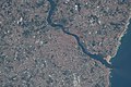 ISS051-E-36340 - View of Earth.jpg 4,928 × 3,280; 2.85 MB
-
 Isula de Malta RMG F1662.tiff 4,843 × 7,312; 101.31 MB
-
 Italia. LOC 99466770.jpg 7,713 × 5,808; 7.88 MB
-
 Italy 1853.jpg 9,032 × 6,464; 21.33 MB
-
 Jaffna.gif 469 × 388; 17 KB
-
 Jilin yu tu. LOC gm71002468.jpg 21,221 × 11,635; 31.64 MB
-
 Joaquín Torres García - América Invertida.jpg 726 × 768; 111 KB
-
.jpg/120px-Les_Villes_de_la_riviere_de_Loire%2C_Rome%2C_et_plusieurs_obiectz_d%27Italie%2C_et_de_France_(BM_1871%2C0513.645).jpg)
-
.jpg/120px-Les_Villes_de_la_riviere_de_Loire%2C_Rome%2C_et_plusieurs_obiectz_d%27Italie%2C_et_de_France_(BM_1874%2C0808.1394).jpg)
-
 MAK GO-1827 1 Globus.jpg 932 × 1,400; 793 KB
-
_(1600).jpg/120px-Map_of_Bohemia_(Czech_Republic)_(1600).jpg) Map of Bohemia (Czech Republic) (1600).jpg 800 × 600; 123 KB
Map of Bohemia (Czech Republic) (1600).jpg 800 × 600; 123 KB
-
.jpg/120px-Map_of_Detroit%2C_Monroe_and_Toledo_Short_Line_Railway_(1905).jpg) Map of Detroit, Monroe and Toledo Short Line Railway (1905).jpg 2,549 × 941; 1.12 MB
Map of Detroit, Monroe and Toledo Short Line Railway (1905).jpg 2,549 × 941; 1.12 MB
-
 Map of Germany 1600.jpg 800 × 600; 124 KB
-
 Map of Germany 1628.jpg 1,024 × 768; 222 KB
-
 Map of Germany NE 1600.jpg 800 × 600; 149 KB
-
 Map of Germany NW 1600.jpg 800 × 600; 147 KB
-
 Map of Germany SE 1600.jpg 800 × 600; 153 KB
-
 Map of Germany SW 1600.jpg 800 × 600; 146 KB
-

-
.jpg/120px-Map_of_Swabia_(1600).jpg) Map of Swabia (1600).jpg 800 × 600; 108 KB
Map of Swabia (1600).jpg 800 × 600; 108 KB
-
 Map of Swabia a detail 1600.jpg 800 × 600; 128 KB
-
 Map of Swabia NE 1600.jpg 800 × 600; 163 KB
-
 Map of Swabia NW 1600.jpg 800 × 600; 158 KB
-
 Map of Swabia SE 1600.jpg 800 × 600; 152 KB
-
 Map of Swabia SW 1600.jpg 800 × 600; 133 KB
-
.jpg/120px-Map_of_Swabia%2C_Bavaria%2C_Odenwald_(1600).jpg) Map of Swabia, Bavaria, Odenwald (1600).jpg 800 × 600; 134 KB
Map of Swabia, Bavaria, Odenwald (1600).jpg 800 × 600; 134 KB
-
 Map of the Berlin region 1600.jpg 800 × 600; 168 KB
-
.tif/lossy-page1-111px-Map_of_the_city_of_New_York_(NYPL_Hades-119494-54125).tif.jpg) Map of the city of New York (NYPL Hades-119494-54125).tif 4,254 × 4,594; 55.92 MB
Map of the city of New York (NYPL Hades-119494-54125).tif 4,254 × 4,594; 55.92 MB
-

-
 Map of the old world.jpg 1,920 × 2,560; 2.08 MB
-
%2C_Čiovo_(Bua)_island%2C_San_Andrea_(Svetac)_island%2C_and_part_o_-_Bordone_Benedetto_-_1547.jpg/120px-Map_of_Trau_island_(today_historical_centre_of_Trogir_city)%2C_Čiovo_(Bua)_island%2C_San_Andrea_(Svetac)_island%2C_and_part_o_-_Bordone_Benedetto_-_1547.jpg)
-
 Map showing "Insula Atlantis", the lost continent of Atlantis LCCN2002698490.jpg 1,536 × 1,026; 290 KB
-
 Map showing the British advance upon Dongola. LOC 2012591520.jpg 2,550 × 3,357; 1.02 MB
-
 Map showing the British advance upon Dongola. LOC 2012591520.tif 2,550 × 3,357; 24.49 MB
-
 Mapa Brazil.jpg 1,168 × 688; 132 KB
-
 Mapa Brazil.webp 1,170 × 700; 32 KB
-
.jpg/120px-Mapa_da_Galiza_no_atlas_de_Pedro_Teixeira_(1634).jpg) Mapa da Galiza no atlas de Pedro Teixeira (1634).jpg 16,959 × 11,210; 24.98 MB
Mapa da Galiza no atlas de Pedro Teixeira (1634).jpg 16,959 × 11,210; 24.98 MB
-
 Mapa de Manuel Centurion Guerrero de Torres 1773.jpg 1,231 × 798; 1.14 MB
-
 Mapa de Raleigh 1595 -.jpg 1,340 × 1,024; 1.46 MB
-
 Mapa de Raleigh 1595 Perez-Gomez et al 2019-.png 1,181 × 988; 2.41 MB
-
 Mapa de Raleigh 1595.jpg 1,500 × 1,024; 1.47 MB
-
 1471 Mappa di Roma - Pietro del Massaio.jpg 790 × 991; 347 KB
-
 Ming Zuling 1590.jpg 582 × 421; 100 KB
-
 Nile-Cairo-Giza.jpg 584 × 846; 314 KB
-
.jpg/120px-Nova_Belgica_Et_Anglia_Nova_-_btv1b8595999k_(1_of_2).jpg) Nova Belgica Et Anglia Nova - btv1b8595999k (1 of 2).jpg 8,240 × 6,332; 8.66 MB
Nova Belgica Et Anglia Nova - btv1b8595999k (1 of 2).jpg 8,240 × 6,332; 8.66 MB
-
.jpg/120px-A_chart_of_EEMS_ELVE%2C_Wefer%2C_Eyder_and_Hever._With_the_Holy_Island_(NYPL_b13909432-1640697).jpg)
-
 Pamet5.jpg 1,344 × 816; 235 KB
-

-
.jpg/120px-Partie_d%27Afrique_depuis_Tabarque_jusqu%27à_Alger_-_btv1b532423107_(1_of_2).jpg) Partie d'Afrique depuis Tabarque jusqu'à Alger - btv1b532423107 (1 of 2).jpg 9,948 × 3,818; 4.03 MB
Partie d'Afrique depuis Tabarque jusqu'à Alger - btv1b532423107 (1 of 2).jpg 9,948 × 3,818; 4.03 MB
-

-
_Beausire_de_La_Grange_-_btv1b53103363g.jpg/120px-thumbnail.jpg)
-

-

-
%2C_BI-B-FM-090-75.jpg/120px-thumbnail.jpg)
-

-
.jpg/120px-Peru_-_descriptore_Joanne_Baptista_Nicolosio..._-_btv1b84699100_(2_of_4).jpg) Peru - descriptore Joanne Baptista Nicolosio... - btv1b84699100 (2 of 4).jpg 9,021 × 6,944; 7.18 MB
Peru - descriptore Joanne Baptista Nicolosio... - btv1b84699100 (2 of 4).jpg 9,021 × 6,944; 7.18 MB

%27_(11074549864).jpg)
%27_(11110787996).jpg)
.jpg)
%27_(11254316323).jpg)


_32.jpg)

_-_Maurice_Bouguereau_und_Jean_Surhon.JPEG)


.jpg)

.jpg)
.jpg)


.jpg)


_-_Geographicus_-_NewYork-hooker-1871.jpg)


_LOC_gm71002482.jpg)


%27_(11008480526).jpg)
.jpg)
.jpg)
%27_(11062806134).jpg)

_(14804664433).jpg)

.jpg)
.jpg)
.jpg)
.jpg)


_-_btv1b6700405t_(08_of_21).jpg)
_-_btv1b6700405t_(12_of_21).jpg)
.jpg)
_-_bpt6k9116854h_(35_of_51).jpg)
rs_de_l%27Academie_Royale_des_Sciences,_par_N._de_Fer_geographe_de_sa_Majesté_Catolique_et_Monseigneur_le..._-_btv1b53247486x_(166_of_328).jpg)
.jpg)
.jpg)
.jpg)
.jpg)
.jpg)
.jpg)

.jpg)


.jpg)


.jpg)
.jpg)


.jpeg)
_111.jpg)
_05.jpg)
_09.jpg)


_07.jpg)


.jpg)


_45.jpg)


_(cropped).jpg)
_(180_degree_rotated).jpg)
_B.jpg)
.jpg)
.jpg)
.jpg)
_(With_plates,_including_a_portrait.)%27_(11001922473).jpg)
.jpg)


.jpg)
.jpg)

_(1600).jpg)


.jpg)


.jpg)


,_Čiovo_(Bua)_island,_San_Andrea_(Svetac)_island,_and_part_o_-_Bordone_Benedetto_-_1547.jpg)


.jpg)


.jpg)
.jpg)


_Beausire_de_La_Grange_-_btv1b53103363g.jpg)


,_BI-B-FM-090-75.jpg)

.jpg)
_Map_of_the_Salt-transport_Canals_in_Jiangsu_Province.png)
_LOC_80692838.jpg)
,_OSM_map_2022.png)
.jpg)
.jpg)
.jpg)
.jpg)